1970-Present
The Growth of Downtown
City Planners in San Francisco believed that downtown needed to be the hub and central part of the city. Whether it was the skyscrapers of the financial district or Market Street and the tourist destinations along with it, downtown needed to be the most recognizable and visually attractive part of the city. In the general plan of San Francisco that was written in 1986, there were 22 objectives to maintain and improve downtown as the sole image of San Francisco. However the three main categories on which the built form of downtown San Francisco is determined are as follows [4]:
San Francisco is a very dense city, with a grid system of streets planned in the early 20th century that doesn’t allow much expansion side to side. City planners in the early 1970’s saw that the only way to add square footage to the buildings of the C-3 district was in the upward direction. It was at this point in time when the skyline of San Francisco began to take form.
Districting downtown San Francisco was very difficult, because the planning committee had many objectives they wished to maintain. The biggest change came when a downtown zoning study was done in 1965 and it was determined that 4 new zones should be created where only 1 downtown zone stood before. These four new zones would be [4]:
- Zoning and a unique, charter-based discretionary-review power
- General standards established by the urban-design plan and standards for important specific sites established by “urban design terms of reference”
- The California Environmental Quality Act
San Francisco is a very dense city, with a grid system of streets planned in the early 20th century that doesn’t allow much expansion side to side. City planners in the early 1970’s saw that the only way to add square footage to the buildings of the C-3 district was in the upward direction. It was at this point in time when the skyline of San Francisco began to take form.
Districting downtown San Francisco was very difficult, because the planning committee had many objectives they wished to maintain. The biggest change came when a downtown zoning study was done in 1965 and it was determined that 4 new zones should be created where only 1 downtown zone stood before. These four new zones would be [4]:
- Downtown Office District: Home to 130 acres of large office buildings and some small retail services
- Downtown Retail District: Requirement for half of buildings to have easily accessible shop windows and doors
- Downtown General Commercial District: Mixture of all sorts of uses from clubs, hotels, and retail.
- Downtown Support District: Allowed for all the things making downtown functional. Also allowed space for office expansion
The Skyscraper Boom
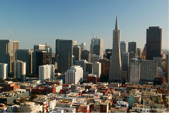
Figure 1: Downtown San Francisco Skyscrapers
One of the main objectives for downtown is to, “Maintain and improve San Francisco’s position as a prime location for financial, administrative, corporate, and professional activity.” [3] In 1980, under Mayor Dianne Feinstein, the Financial District of San Francisco saw a boom of growth in the form of skyscrapers. These high-rise buildings were home to many offices and major companies. This skyscraper phenomenon moved into the residential areas as high-rise apartment buildings went into place as well. It was from the early 1970’s and on that downtown San Francisco became this area for big business and major corporate headquarters. In the years from 1965-1981 the square footage of office space more than doubled from 26 million to 55 million [3].
With these buildings going up, revolts started surfacing as well. Height restrictions were placed on buildings that slowed down the construction of skyscrapers through the 1990’s. Throughout the past decade however a serious housing shortage in the city has caused the height restrictions to be relaxed. Housing skyscrapers are going up like the all-residential South Tower located at One Rincon Hill [2]. City planners needed to find space for offices and housing without destroying any of the minimal amounts open space present in downtown. At this point in time the need for more jobs, office space, and housing over-powered the battles of the height restrictions. The skyscrapers were being built taller than ever now, with some present plans of buildings surpassing 1000 feet tall [2]. The city’s skyline ranks as the second tallest on the west coast and sixth tallest in the country. The “Manhattanization” that Mayor Feinstein proposed for the financial district and downtown has become a reality. San Francisco has 21 skyscrapers that pass for over 492 feet tall [2].
The C-3-O district of downtown is the main financial, corporate, and business sector. In this district is where there is the most competition for office space. Over 42 million square feet of office space is present in this district of downtown and new construction is still increasing that number. They are trying to fit as many square feet into the C-3-O district as possible. Other districts are also increasing their amount of square footage by the millions: 9 million in C-3-G, 5 million in C-3-R, and another 5 million in C-3-S [3].
The Retail District
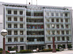
Figure 2: Macy's in Union Square
Another main objective is to promote downtown San Francisco as a main retail market and tourist destination. Planners of downtown wanted it to be known as a place of fine and popular retail, “Improve downtown San Francisco’s position as the region’s prime location for specialized retail trade” [3] The C-3 district currently houses 8.2 million square feet of shops, which in turn employs over 20,000 people [3]. Union Square is home to many the most expensive and popular shops and hotels in the world and ranks as one of the top downtown retail areas in the country. In order to do this and not be solely just a business focused downtown the city would need to cater to the day workers of the C-3 district. Planners made sure that the middle and lower class had shops and restaurants that they could afford. If this were not the case, downtown would not be a realistic place for everyone to travel and enjoy. The retail district was one that needed to be very reachable to the visiting population of downtown. It was zoned around Union Square a main tourist destination and also next to the General Commercial district that is home to many of the hotels of downtown.
The retail district through an urban design perspective was built to be easily accessible to those walking the streets. It is a policy of the district that retail must be the primary use of the ground level [3]. This type of urban design is very appealing to the common passerby on the street and one of the reasons that the retail district and consumer market in San Francisco has been so successful.
The retail district through an urban design perspective was built to be easily accessible to those walking the streets. It is a policy of the district that retail must be the primary use of the ground level [3]. This type of urban design is very appealing to the common passerby on the street and one of the reasons that the retail district and consumer market in San Francisco has been so successful.
The General Commercial District
In order for people to travel to downtown San Francisco and enjoy it for long periods of time the hotel and entertainment industries had to be specifically planned and located as well. Hotels needed to be placed in and throughout downtown to promote accessibility to retail centers. The 60 hotels in downtown are built mainly in the C-3-G and C-3-S districts surrounding Union Square [3], this is definitely not by chance. City Planners avoided planning hotels in the C-3-O districts and focused more on the location of the shops. They wanted the shops to be in a separate part of the city to avoid congestion and over planning, but this makes downtown more organized and the close proximity of shops helps promote walking to and from the visitor hotels.
This is an example of what was found in the zoning planning study that originally determined four zones were much more efficient. Placing hotels near the retail district in the general commercial district helps move people in the direction the planners want them to move. Now traffic and public transportation lines can be planned accordingly to where office workers are coming from and where the tourists are coming from. The planning commission and zoning committee wanted the districts to feed off of each other as opposed to infringing on each other. This way of zoning helps separate the main attractions of the city in an organized and coherent matter.
Along with the hotels that housed everyone visiting San Francisco the zoning committee saw the General Commercial District as a place of entertainment, institutions, and less condensed buildings [4]. Since this district was zoned and planned to be less congested parking lots were constructed here. This district was much more auto-oriented than the Office and Retail districts. It allowed for special-use that was under the opinion of the planning commission. This district was zoned to have entertainment options that weren’t available through retail shopping centers; it housed the tourist staying in downtown and allowed easy pedestrian access to the other districts of downtown.
Market Street
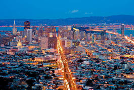
Figure 3: Market Street at night.
The biggest avenue in San Francisco is Market Street, and it can be seen from a bird’s eye view above the city very clearly. It is a 120-foot wide street that runs from one end of the city to the other which ends directly in front of the Ferry Building on The Embarcadero [4]. It looks as if it almost divides the city into two halves and is very comparable to the Avenue des Champs Elysees in Paris, France. City planners wanted this avenue to sustain the many vistas along the route, so nothing impedes your view from one end to the other. Market Street is home to all of the districts of downtown. It runs from the downtown office district (C-3-O), through the retail sector (C-3-R), up into the General commercial (C-3-G) and Service (C-3-S) districts. Market Street sees all kinds of transportation services, from Muni buses, trolleybuses, and regular streetcars. Market Street was redesigned in 1971 when the construction of the Bay Area Rapid Transit (BART) was completed [5]. Planners designed Market Street to be an avenue that has access to any part of the city, and any form of entertainment or work throughout the day in downtown.
In looking at the urban design of Market St. many objectives were based toward pedestrians walking the avenue. Bonus areas were made with plazas and places for people to sit and relax. This development didn’t become a way to design until after the buildings were made. So after the redevelopment of Market St. it was found that many of the buildings were poorly designed along the avenue. Due to this poor design of buildings adjacent to the street there is quite a large amount of wasted space that could have been utilized much better as pedestrian walkways and/or plazas.
In looking at the urban design of Market St. many objectives were based toward pedestrians walking the avenue. Bonus areas were made with plazas and places for people to sit and relax. This development didn’t become a way to design until after the buildings were made. So after the redevelopment of Market St. it was found that many of the buildings were poorly designed along the avenue. Due to this poor design of buildings adjacent to the street there is quite a large amount of wasted space that could have been utilized much better as pedestrian walkways and/or plazas.
Transportation
The transportation infrastructure of downtown is good but not great. The plan does not call for widening the roads and more parking structures in downtown. It calls for 2 things [3].
- Increase the number of commuters per vehicle
- Increase the number of commuters using transit
Open Space Development
Along with all of the high rises and buildings being constructed to meet the demand for more office space and housing, the biggest issue and concern for the downtown planning commission is maintaining and creating more open space. The formal objective is as follows “Provide quality open space in sufficient quantity and variety to meet the needs of downtown workers, residents, and visitors.” With the increasing population and overall growth of downtown, creating more and even maintaining the already existing open space is quite an arduous challenge. The C-3 district of downtown is very condensed, not a lot of open space is present or available. The goal of General Plan is any person should be at the most 900 feet away from an area designated as an open space [3]. Whether it is a grassy park or a small sunlit plaza. Before some of the policies came to be in this General Plan, a lot of high rises were constructed in a way in which a sunlit area no longer existed. Before the policies of the General Plan and the height restrictions of the 80’s were put into effect, the open space in downtown was not thought of as something to maintain. These skyscrapers were built directly blocking sunlit plazas and in turn destroying the open space.
In downtown now most of the existing open space is near The Embarcadero and the piers. In C-3-O not a lot of open space is present, the office building skyscrapers are packed very tightly together. Some of the biggest challenges are making open spaces that are street level and open to the public. City planners know that having elevated open spaces, per say on a roof or upper floor of a high-rise building are less inviting to the general public and not used as frequently. The challenge comes to working with the mistakes planners and contractors have already made in downtown and trying to improve upon them.
In downtown now most of the existing open space is near The Embarcadero and the piers. In C-3-O not a lot of open space is present, the office building skyscrapers are packed very tightly together. Some of the biggest challenges are making open spaces that are street level and open to the public. City planners know that having elevated open spaces, per say on a roof or upper floor of a high-rise building are less inviting to the general public and not used as frequently. The challenge comes to working with the mistakes planners and contractors have already made in downtown and trying to improve upon them.
Present San Francisco
All of these different parts of the city must come together to make downtown San Francisco attractive for people who want to come to visit. When the city was being built the planners were taking the city’s size, population, and land area into consideration, and now as the city grows they must not forget about all of the aspects that make downtown what it is.
1. Goodman, Joseph. “Curtiba’s Bus System is Model for Rapid Transit” Race, Poverty, and the Environment. Spring 2007. February, 2013.
2. “San Francisco Statistics” Emporis. February, 2013 http://www.emporis.com/city/sanfrancisco-ca-usa
3. San Francisco Planning Department. “Downtown Area Plan” The San Francisco General Plan. 1986. February, 2013 http://www.sf-planning.org/ftp/general_plan/downtown.htm
4. Cook, Robert S. Zoning for Downtown Urban Design: San Francisco. Lexington: LexingtonBooks, 1980. Pages (121-139)
5. “A History of BART: The Project Begins” Bay Area Rapid Transit. February, 2013 http://www.bart.gov/about/history/history2.aspx
6. Hartman, Chester. City for Sale: The Transformation of San Francisco. University of California Press. 2002. Pages (155-189)
7. United States Census Bureau. “San Francisco, (City)”. April 2011. http://quickfacts.census.gov/qfd/states/06/0666140.html
